
Archivo: Bayamon Puerto Rico aerial view

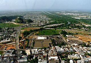
Description: Aerial view of Bayamón, Puerto Rico. The U.S. Army Corps of Engineers has constructed a flood control project on the Rio de Bayamón through the city. View is to the north towards the Atlantic Ocean. The Canton Mall is visible in the center of the picture.
Title: Bayamon Puerto Rico aerial view
Credit: U.S. Army Corps of Engineers Digital Visual Library Image page Image description page Digital Visual Library home page
Author: Tony Santana, U.S. Army Corps of Engineers
Permission: This image or file is a work of a U.S. Army Corps of Engineers soldier or employee, taken or made as part of that person's official duties. As a work of the U.S. federal government, the image is in the public domain. English | italiano | Nederlands | русский | Türkçe | українська | +/−
Usage Terms: Public domain
License: Public domain
Attribution Required?: No
Usos del archivo
La siguiente página enlaza a este archivo:
