
Archivo: 1858 Mexico Map Civil War Divisions

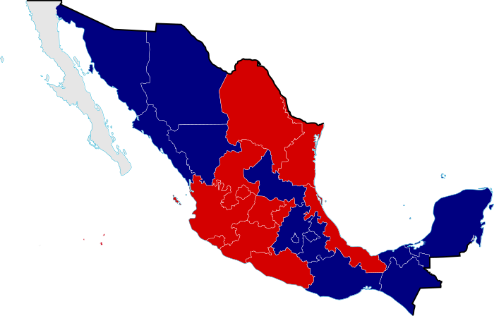
Descripción: Mexico Civil War Division Map in 1858, the Mexican Civil War was one of the episodes of the long struggle between Liberal and Conservative forces that dominated the country's history in the 19th century, because the Liberals wanted a federalist government, limiting traditional Catholic Church and military influence in the country, meanwhile the Conservatives wanted a centralist government, even a monarchy with the Church and military keeping their traditional roles and powers.
Título: 1858 Mexico Map Civil War Divisions
Créditos: Conservative support Liberal support Independent Tacubaya Plan States that supported the Tacubaya Plan by Félix María Zuloaga Chihuahua (247,087 km²) Durango (123,181 km²) Sonora (182,052 km²) Sinaloa (58,328 km²) Puebla (34,251 km²) Tabasco (25,267 km²) Tlaxcala (4,016 km²) México (48,295 km²) Chiapas (73,211 km²) Oaxaca (93,952 km²) Yucatán (151,515 km²) Reform Laws States that supported the Reform Laws by Benito Juárez García Nuevo León (64,924 km²) Coahuila (151,571 km²) Tamaulipas (79,384 km²) San Luis Potosi (63,068 km) Guanajuato (30,608 km²) Querétaro (11,658 km²) Jalisco (107,365 km²) Colima (5,191 km²) Veracruz (71,820 km²) Michoacán (59,928 km²)Independent The commander Diego Castilla forced all municipalities to recognize the Plan of Tacubaya but the commander was deposed from his post, thus, due to the distance of Benito Juárez, the governments of the North and South parties decided in Baja California to take its own independent government [1]. Baja California (143,396 km²)
Autor(a): Giggette
Términos de Uso: Creative Commons Attribution-Share Alike 3.0
Licencia: CC BY-SA 3.0
Enlace de Licencia: https://creativecommons.org/licenses/by-sa/3.0
¿Se exige la atribución?: Sí
Usos del archivo
La siguiente página enlaza a este archivo:
