
Archivo: 1845 trailmap

Tamaño de esta previsualización: 800 × 475 píxeles. Otras resoluciones: 320 × 190 píxeles | 993 × 589 píxeles.
Archivo original (993 × 589 píxeles; tamaño de archivo: 37 KB; tipo MIME: image/png)
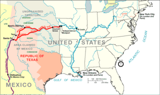
Description: Santa Fe Trail around 1845 plus connecting trading routes to commercial hubs and ports in the USA
Title: 1845 trailmap
Credit: http://www.nps.gov/beol/trailmap.gif
Author: NPS-graphics
Permission: This image or media file contains material based on a work of a National Park Service employee, created as part of that person's official duties. As a work of the U.S. federal government, such work is in the public domain in the United States. See the NPS website and NPS copyright policy for more information.
Usage Terms: Public domain
License: Public domain
Attribution Required?: No
Usos del archivo
Las siguientes páginas enlazan a este archivo:

Todo el contenido de los artículos de la Enciclopedia Kiddle (incluidas las imágenes) se puede utilizar libremente para fines personales y educativos bajo la licencia Atribución-CompartirIgual a menos que se indique lo contrario.