
Archivo: 1827 Finley Map of Mexico, Upper California and Texas - Geographicus - Mexico-finely-1827

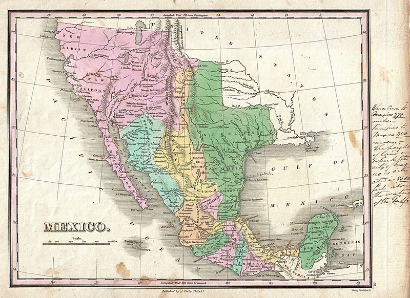
Descripción: A scarce and important 1827 map of Mexico by Anthony Finley. Covers from upper California and New Albion south to Guatemala, including the modern day regions of California, New Mexico, Arizona, Colorado, Utah, Nevada, Texas and Mexico. Offers an interesting pre-Republic mapping of Texas folded into the Intendency of San Louis Potosi. Here New Mexico, previously a vast territory, is limited to a narrow sliver of land attached to the upper Rio Norte or Rio Grande. Further west this map really gets interesting with the explorations of Escalante and Humboldt very much in evidence. Finley curiously charts two lakes in the Great Basin, one labeled Timpanagos and another smaller lake further south labeled Salt Lake. The Great Salt Lake is said to have first been seen by Europeans in 1824, only a few years before this map was published, so it is unlikely that Finley drew from this exploration. Instead, Finely is following Escalante's discoveries as recorded on the Miera map. The Escalante expedition actually visited Utah Lake (Timpanagos), but only heard about the Great Salt Lake from local native American Ute tribe. Miera, Escalante's cartographer, thus mapped Timpanagos as much larger than the unseen Great Salt Lake. Finley also maps the Buenaventura River running from the Rocky Mountains westward through Salt Lake and westward to San Francisco Bay. The Buenaventura is the last incarnation of the apocryphal River of the West, a long sought after speculative alternative to the Northwest Passage. The mapping of Buenaventura here again references legitimate discoveries by Escalante of the White River and the Sevier River. In this case, both are mistakenly associated with the River of the West and given an erroneous outlet into San Francisco Bay. In addition to geographical notations, Finley also identifies a number of American Indian nations including the Moqui, Apache, Juma, Nochi, Poagos and Yahipias (with long beards). Engraved by Young and Delleker for the 1827 edition of Anthony Finley's General Atlas .
Título: Mexico.
Créditos: This file was provided to Wikimedia Commons by Geographicus Rare Antique Maps, a specialist dealer in rare maps and other cartography of the 15th, 16th, 17th, 18th and 19th centuries, as part of a cooperation project.
Autor(a): Anthony Finley
Permiso: Esta es una reproducción fotográfica fiel de una obra de arte bidimensional de dominio público. La obra de arte misma se halla en el dominio público por el motivo siguiente: Public domainPublic domainfalsefalse Este material está en dominio público en los demás países donde el derecho de autor se extiende por 100 años (o menos) tras la muerte del autor. También debes incluir una etiqueta de dominio público de los Estados Unidos para indicar por qué esta obra está en el dominio público en los Estados Unidos. Esta obra ha sido identificada como libre de las restricciones conocidas en virtud del derecho de autor, incluyendo todos los derechos conexos. https://creativecommons.org/publicdomain/mark/1.0/PDMCreative Commons Public Domain Mark 1.0falsefalse La postura oficial de la Fundación Wikimedia considera que «las reproducciones fieles de obras de arte bidimensionales de dominio público forman parte del dominio público». Esta reproducción fotográfica, por ende, también se considera de dominio público dentro de los Estados Unidos. Es posible que otras jurisdicciones restrinjan la reutilización de este contenido; consúltese Reutilización de fotografías PD-Art (en inglés) para más detalles.
Términos de Uso: Dominio Público
Licencia: Dominio Público
¿Se exige la atribución?: No
Usos del archivo
La siguiente página enlaza a este archivo:
