
Archivo: 1702 Visscher Stoopendaal Map of Israel, Palestine or the Holy Land - Geographicus - PerigrinatiaeVeertich-stoopendaal-1702

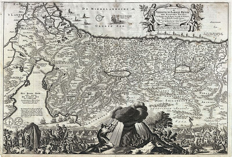
Descripción: An absolutely stunning 1702 ', Israel, or Palestine — by N. Visscher and D. Stoopendaal. This map, from Keur's important Dutch Bible of 1702, is oriented to west and covers from the Nile Delta, Cairo and Memphis, Egypt, across the Red Sea and along the Mediterranean Coast as far north as Sidon and Tyre (Lebanon), and further inland, Palmyra. Cartographically this map hails from the Nicholas Visscher map of 1650, but it does exhibit some modifications including completely revised topical imagery in the lower quadrants. Like Visscher's map, our Biblical map shows the course of the Israelites as they fled out of Egypt (c. 14th century BCE), across the Red Sea, and subsequently spent the next forty years wandering in the Sinai before migrating into the Promised Land by crossing the Jordan river just north of the Dead Sea. Mt. Sinai, Mt. Horeb, Sodom, Gomorra, Jerusalem, and countless other importable Biblical locals are noted. In the Mediterranean a fleet of ships is transporting cedar from Sidon to Jaffa for the construction of Solomon's Temple. Also in the Mediterranean, there is an illustration Jonah being swallowed by the whale. These are the only two decorative elements that are inherited directly from Visscher's map of 1650. The elaborate decorative engraving work in the lower quadrants of the map is the work of Stoopendaal, a Dutch engraver active in Amsterdam during the late 17th and early 19th centuries. Stoopendaal's elaborate illustrations depicts various scenes from Exodus including Moses receiving the Tables of Law, the encampments of the Israelites, Moses producing water from a stone, etc. A truly beautiful map and one of the finest maps to appear in an 18th century Bible.
Título: Perigrinatie ofte Veertich-Iarige Reyse der Kinderen Israels
Créditos: This file was provided to Wikimedia Commons by Geographicus Rare Antique Maps, a specialist dealer in rare maps and other cartography of the 15th, 16th, 17th, 18th and 19th centuries, as part of a cooperation project.
Autor(a): http://www.geographicus.com/mm5/cartographers/stoopendaald.txt
Permiso: Esta es una reproducción fotográfica fiel de una obra de arte bidimensional de dominio público. La obra de arte misma se halla en el dominio público por el motivo siguiente: Public domainPublic domainfalsefalse Este material está en dominio público en los demás países donde el derecho de autor se extiende por 100 años (o menos) tras la muerte del autor. También debes incluir una etiqueta de dominio público de los Estados Unidos para indicar por qué esta obra está en el dominio público en los Estados Unidos. Esta obra ha sido identificada como libre de las restricciones conocidas en virtud del derecho de autor, incluyendo todos los derechos conexos. https://creativecommons.org/publicdomain/mark/1.0/PDMCreative Commons Public Domain Mark 1.0falsefalse La postura oficial de la Fundación Wikimedia considera que «las reproducciones fieles de obras de arte bidimensionales de dominio público forman parte del dominio público». Esta reproducción fotográfica, por ende, también se considera de dominio público dentro de los Estados Unidos. Es posible que otras jurisdicciones restrinjan la reutilización de este contenido; consúltese Reutilización de fotografías PD-Art (en inglés) para más detalles.
Términos de Uso: Dominio Público
Licencia: Dominio Público
¿Se exige la atribución?: No
Usos del archivo
La siguiente página enlaza a este archivo:
