
Archivo: Zambezi river basin-fr

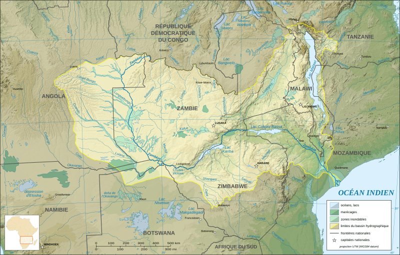
Descripción: Map in French of the Zambezi river hydrographic basin, Africa.
Título: Zambezi river basin-fr
Créditos: Trabajo propio (Texto original: «Own work ; Topographic background map : NASA Shuttle Radar Topography Mission (SRTM30 v.2) (public domain) edited with MicroDEM and dlgv32 Pro / Global Mapper ; UTM projection ; WGS84 datum ; References for the additional data : Demis World Map data (see the approval e-mail and the Demis forum) and UNESCO map ; Locator map : File:Africa map blank.svg (modified) created by myself.»)
Autor(a): Eric Gaba (Sting - fr:Sting)
Permiso: Attribution and Share-Alike required Any use of this map can be made as long as you credit me (Eric Gaba – Wikimedia Commons user: Sting) as the author and distribute the copies and derivative works under the same license(s) that the one(s) stated below. A message with a reply address would also be greatly appreciated.
Términos de Uso: Creative Commons Attribution-Share Alike 3.0
Licencia: CC-BY-SA-3.0
Enlace de Licencia: http://creativecommons.org/licenses/by-sa/3.0/
¿Se exige la atribución?: Sí
Usos del archivo
Las siguientes páginas enlazan a este archivo:
