
Archivo: Yellowstone Caldera map2 750px
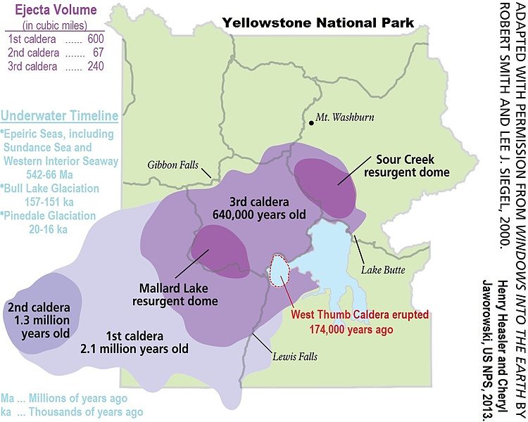
Descripción: Map of the Yellowstone Caldera. (1) This 2013 publication by United States National Park Service at web posting replaces previous USGS map, File:Yellowstone Caldera map2.jpg. The older diagram, File:Yellowstone Caldera map2.jpg, is posted on-line as "fig_03_yellowstone_map.jgp," dated 14 March 14 2005. Very similar map, but nevertheless some minor changes were made over the elapsed 8 years. Specifically, the northernmost "uncertain boundary" for the 1st caldera has been replaced. (2) Note that West Thumb Caldera (44°25′40″N 110°31′57″W) is not to be confused with West Thumb Geyser Basin (44°25′07″N 110°34′23″W). Per the US NPS, West Thumb Lake is itself a smaller caldera. See Figure 22 at US NPS web site. West Thumb Caldera forms West Thumb Lake, and West Thumb Geyser Basin lies on the western shore of West Thumb Lake. Source: US NPS.
Título: Yellowstone Caldera map2 750px
Créditos: https://en.wikipedia.org/wiki/File:Yellowstone_Caldera_map2.JPG
Autor(a): National Park Service
Términos de Uso: Dominio Público
Licencia: Dominio Público
¿Se exige la atribución?: No
Usos del archivo
La siguiente página enlaza a este archivo:
