
Archivo: World map 1815 (COV)

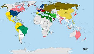
Descripción: A map of the world in the year 1815 AD. States shown in colours: Britain (pink), France (navy blue), Sweden (dark blue), Prussia (dark grey), the states of the German Confederation (pink), Austria (burgundy), Spain (yellow), Portugal (green-turquoise), Ottoman Empire (dark green), Iran (light green), Russia (brown), Netherlands (orange), Sardinia/Savoy (lime green), China (cream-yellow), Japan (bright red), Denmark (dull red), Oman (maroon-purple), USA (dark blue, similar to Sweden). All other states shown in white. Terra Nullis shown in grey.
Título: World map 1815 (COV)
Créditos: Trabajo propio
Autor(a): SvoHljott
Términos de Uso: Creative Commons Attribution-Share Alike 3.0
Licencia: CC BY-SA 3.0
Enlace de Licencia: https://creativecommons.org/licenses/by-sa/3.0
¿Se exige la atribución?: Sí
Usos del archivo
La siguiente página enlaza a este archivo:
.jpg&oldid=3102923)

.jpg)