
Archivo: Wacht am Rhein map (Opaque)-es

Tamaño de esta previsualización PNG del archivo SVG: 371 × 599 píxeles. Otra resolución: 148 × 240 píxeles.
Archivo original (archivo SVG, nominalmente 557 × 900 píxeles, tamaño de archivo: 216 KB)
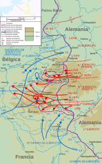
Descripción: Map of the opening of the salient, the start of the Battle of the Bulge (German: Wacht am Rhein, "Watch on the Rhine"). Map covers 16 – 25 December 1944.
Título: Wacht am Rhein map (Opaque)-es
Créditos: Wacht am Rhein map (Opaque).svg
Autor(a): Wacht am Rhein map (Opaque).svg:Matthewedwards (discusión · contribs.) derivative work: rowanwindwhistler (discusión)
Términos de Uso: Creative Commons Attribution-Share Alike 4.0
Licencia: CC BY-SA 4.0
Enlace de Licencia: https://creativecommons.org/licenses/by-sa/4.0
¿Se exige la atribución?: Sí
Usos del archivo
La siguiente página enlaza a este archivo:
-es.svg&oldid=3004441)

Todo el contenido de los artículos de la Enciclopedia Kiddle (incluidas las imágenes) se puede utilizar libremente para fines personales y educativos bajo la licencia Atribución-CompartirIgual a menos que se indique lo contrario.
-es.svg)