
Archivo: Utah Territory, vector image - 2011

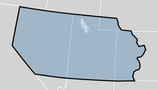
Descripción: The Utah Territory shown as established by the United States Congress in 1850. The map is underlaid with a modern map of the United States showing the current state boundaries. The territory's boundaries may not be exact.
Título: Utah Territory, vector image - 2011
Créditos: Blank_US_Map.svg Wpdms utah territory 1851 idx.png File:1855 Colton Map of Utah and New Mexico (first edition, first state) - Geographicus - UtahNewMexico-colton-1855.jpg
Autor(a): derivative work: Mangoman88 (talk) Blank_US_Map.svg: User:Theshibboleth Wpdms utah territory 1851 idx.png: User:Tsujigiri
Términos de Uso: Creative Commons Attribution-Share Alike 3.0
Licencia: CC-BY-SA-3.0
Enlace de Licencia: http://creativecommons.org/licenses/by-sa/3.0/
¿Se exige la atribución?: Sí
Usos del archivo
La siguiente página enlaza a este archivo:
