
Archivo: Thumbnail Sark

Tamaño de esta previsualización PNG del archivo SVG: 607 × 600 píxeles. Otra resolución: 243 × 240 píxeles.
Archivo original (archivo SVG, nominalmente 1352 × 1336 píxeles, tamaño de archivo: 23 KB)
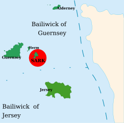
Descripción: Map of the Channel Islands. Note: This image is a simplified version of Image:Channel Islands.svg. It is to serve as a thumbnail in the article about Sark and shall also show the position of the island there.
Título: Thumbnail Sark
Créditos: Trabajo propio
Autor(a): Hannes2 (me), using PD Maps (see this and that) from the CIA World Fact Book for the shapes of the Islands and a PD NASA satellite image (see this) for their position and the shape of the French Coast.
Términos de Uso: Creative Commons Attribution-Share Alike 3.0
Licencia: CC-BY-SA-3.0
Enlace de Licencia: http://creativecommons.org/licenses/by-sa/3.0/
¿Se exige la atribución?: Sí
Usos del archivo
La siguiente página enlaza a este archivo:

Todo el contenido de los artículos de la Enciclopedia Kiddle (incluidas las imágenes) se puede utilizar libremente para fines personales y educativos bajo la licencia Atribución-CompartirIgual a menos que se indique lo contrario.