
Archivo: The Mid-Atlantic States

Tamaño de esta previsualización: 800 × 520 píxeles. Otras resoluciones: 320 × 208 píxeles | 1513 × 983 píxeles.
Archivo original (1513 × 983 píxeles; tamaño de archivo: 43 KB; tipo MIME: image/png)
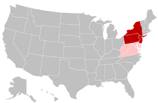
Descripción: Map of the Mid-Atlantic United States. Red shading indicates the states most commonly defined as the Mid-Atlantic in their entirety (i.e. the southern portion of the Northeast) by public sector agencies and private organizations. Pink shading indicates states that are grouped in the region less frequently.
Título: The Mid-Atlantic States
Créditos: Modified from: File:BlankMap-USA-states.PNG
Autor(a): Grayshi, Roke, Maher-shalal-hashbaz
Términos de Uso: Creative Commons Attribution-Share Alike 3.0
Licencia: CC BY-SA 3.0
Enlace de Licencia: https://creativecommons.org/licenses/by-sa/3.0
¿Se exige la atribución?: Sí
Usos del archivo
La siguiente página enlaza a este archivo:

Todo el contenido de los artículos de la Enciclopedia Kiddle (incluidas las imágenes) se puede utilizar libremente para fines personales y educativos bajo la licencia Atribución-CompartirIgual a menos que se indique lo contrario.