
Archivo: Taxodium mucronatum range map

Tamaño de esta previsualización: 795 × 600 píxeles. Otras resoluciones: 318 × 240 píxeles | 908 × 685 píxeles.
Archivo original (908 × 685 píxeles; tamaño de archivo: 61 KB; tipo MIME: image/png)
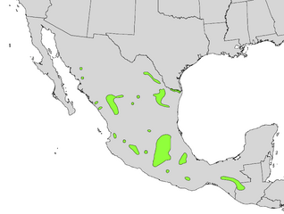
Description: Range distribution map of Taxodium mucronatum — Montezuma cypress, in North America.
Title: Taxodium mucronatum range map
Credit: Digital representation of "Atlas of United States Trees" by Elbert L. Little, Jr. [1]
Author: U.S. Geological Survey
Permission: This image is in the public domain in the United States because it only contains materials that originally came from the United States Geological Survey, an agency of the United States Department of the Interior. For more information, see the official USGS copyright policy.
Usage Terms: Public domain
License: Public domain
Attribution Required?: No
Usos del archivo
La siguiente página enlaza a este archivo:

Todo el contenido de los artículos de la Enciclopedia Kiddle (incluidas las imágenes) se puede utilizar libremente para fines personales y educativos bajo la licencia Atribución-CompartirIgual a menos que se indique lo contrario.