
Archivo: Tang outline map, 661

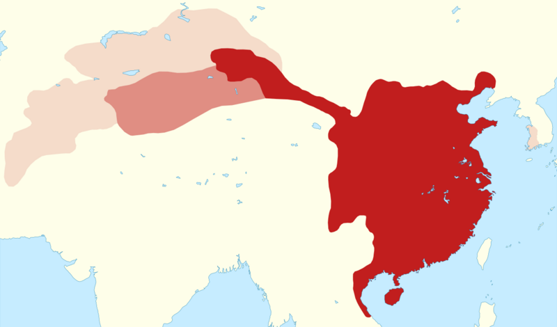
Descripción: Outline map of the Tang empire in 661, when it reached its greatest extent.
Título: Tang outline map, 661
Créditos: Trabajo propio Boundaries from Twitchett, Denis and Wechsler, Howard J. (1979), "Kao-tsung (reign 649–83) and the Empress Wu: The Inheritor and the Usurper", in Denis Twitchett and John Fairbank (eds.), The Cambridge History of China, Volume 3: Sui and T'ang China, 589–906, Part I, Cambridge University Press, ISBN 978-0-521-21446-9, Maps 8 (p. 281) and 9 (p. 283). Blunden, Caroline and Elvin, Mark (1983), Cultural Atlas of China, Oxford: Phaidon Press, ISBN 0-7148-2309-0, pp. 26, 92–93. Shin, Michael D. , ed. (2014) Korean History in Maps, Cambridge University Press, pp. 39, 47 ISBN: 978-1-107-09846-6. (pre-conquest extent of Baekje, approximating the extent of the Ungjin Commandery) Coastline and lakes from Natural Earth 1:50m Physical Vectors Conversion to SVG using svgis
Autor(a): Kanguole
Términos de Uso: Creative Commons Attribution-Share Alike 4.0
Licencia: CC BY-SA 4.0
Enlace de Licencia: https://creativecommons.org/licenses/by-sa/4.0
¿Se exige la atribución?: Sí
Usos del archivo
La siguiente página enlaza a este archivo:
