
Archivo: Sprockhövel in EN

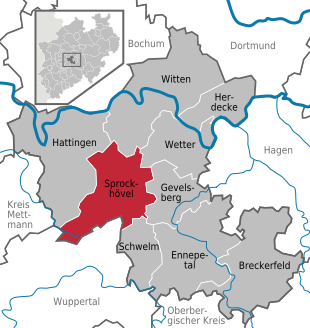
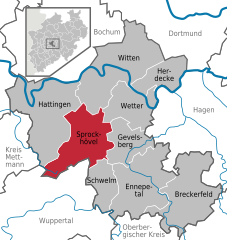
Description: Deutsch (de): Lagekarte von Sprockhövel, Ennepe-Ruhr-Kreis, Nordrhein-Westfalen, Deutschland. markierte Kommune andere Kommune im Gemeindeverband andere Kommunen im Landkreis andere Landkreise im (Bundes-)land Sitz der Verwaltung eines Gemeindeverbands ausländische Staaten andere (Bundes-)Länder Seen und Meere Flüsse und Küstenlinien See also: Projekt Landkreiskarten English (en): Locator map of Sprockhövel in Ennepe-Ruhr-Kreis, North Rhine-Westphalia, Germany. highlighted municipality other municipalities in administrative body (Gemeindeverband, etc.) other municipalities in same district other districts in same state administrative centre of a municipalities association foreign countries other german states lakes and seas rivers and coastlines See also: Projekt Landkreiskarten (German) français (fr): Plan de localisation de la municipalité Sprockhövel dans L'arrondissement d'Ennepe-Ruhr dans Rhénanie-du-Nord-Westphalie, Allemagne. la municipalité marqués autres municipalités dans le même canton (Amt) autres municipalités dans le même arrondissement autres arrondissements dans le même Land siège de l'administration d'un syndicat intercommunal autres pays autres Länder allemands lacs et mers rivières Voir aussi: Projet Landkreiskarten (allemand) hornjoserbsce (hsb): Poziciska karta gmejny Sprockhövel, Ennepe-Ruhr-Kreis, Nordrhein-Westfalen, Němska. wuzběhnjena gmejna druhe gmejny w administratiwnym zwjazku (zarjadniski zwjazk etc.) druhe gmejny w samsnym wokrjesu druhe wokrjesny w samsnym kraju administratiwne srjedźišćo gmejnskeho zwjazka wukraj druhe němske kraje jězory a morja rěki a pobrjóhi Hlej tež: projekt Landkreiskarten (němsce) македонски (mk): Положбена карта на Sprockhövel во рамките на Ennepe-Ruhr-Kreis, Nordrhein-Westfalen, Германија. обележана општина други општини во управната единица (општинско здружение итн.) други општини во истиот округ други окрузи во истата покраина седиште на општинското здружение странски земји други германски покраини езера и мориња реки и брегови Поврзано: Проект „Окружни карти“ (германски) Nederlands (nl): Detailkaart van Sprockhövel in de Ennepe-Ruhr-Kreis, Nordrhein-Westfalen, Duitsland. gemarkeerde gemeente andere gemeenten in het gemeenteverband andere gemeenten in de landkreis andere landkreise in de deelstaat Bestuurszetel van een gemeenteverband andere landen andere deelstaten meren en zeeën rivieren en kustlijnen Zie ook: Projekt Landkreiskarten (Duits) Esperanto (eo): Situomapo de Sprockhövel en Ennepe-Ruhr-Kreis, Nordrhein-Westfalen, Germanio. akcentita komunumo aliaj komunumoj en administra kunumunaro aliaj komunumoj en sama distrikto aliaj distriktoj en sama federacia lando administra centro de kunumunaro ŝtatoj krom Germanio aliaj federaciaj landoj de Germanio lagoj kaj maroj riveroj kaj marbordoj Vidu ankaŭ: Projekt Landkreiskarten (germane) മലയാളം (ml): ജർമ്മനിയിലെ North Rhine-Westphalia, Ennepe-Ruhr-Kreis, Sprockhövel ഭൂപടസ്ഥാനം. എടുത്തുകാണിക്കുന്ന നഗരസഭ ഭരണതലത്തിലുള്ള മറ്റ് നഗരസഭകൾ (ഗെമിൻഡർവാർഡ്, തുടങ്ങിയവ.) അതേ ജില്ലയിലുള്ള മറ്റ് നഗരസഭകൾ അതേ സംസ്ഥാനത്തുള്ള മറ്റ് ജില്ലകൾ നഗരസഭാ സമിതിയുടെ ഭരണനിർവഹണ കേന്ദ്രം വിദേശരാജ്യങ്ങൾ മറ്റ് ജർമ്മൻ സംസ്ഥാനങ്ങൾ തടാകങ്ങളും കടലുകളും നദികളും തീരപ്രദേശങ്ങളും ഇതും കാണുക: Projekt Landkreiskarten (German)
Title: Sprockhövel in EN
Credit:
Author: TUBS
Usage Terms: Creative Commons Attribution-Share Alike 3.0
License: CC BY-SA 3.0
License Link: https://creativecommons.org/licenses/by-sa/3.0
Attribution Required?: Yes
Usos del archivo
La siguiente página enlaza a este archivo:
