
Archivo: Skálholt-Karte
No disponible en mayor resolución.
Skálholt-Karte.png (341 × 398 píxeles; tamaño de archivo: 290 KB; tipo MIME: image/png)
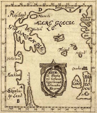
Description: The Skálholt-map made by the icelandic teacher Sigurd Stefansson in the year 1570. Description Greenlands from Bjørn Jonsen of Skarsaa in Iceland from the year 1669, latin by Theodor Thorlac. Note: Helleland ('Stone Land'=Baffin island) Markland ('forest land'=Labrador) Skrælinge Land ('land of the savages'=Labrador) Promontorium Vinlandiæ (the of Vinland=Newfoundland)
Title: Skálholt-Karte
Credit: Sigurd Stefánsson - Beschreibung Grönlands und die Skálholt-Karte
Author: Sigurd Stefánsson - Copy by Jörg Schulz
Usage Terms: Public domain
License: Public domain
Attribution Required?: No
Usos del archivo
No hay páginas que enlacen a esta imagen.

Todo el contenido de los artículos de la Enciclopedia Kiddle (incluidas las imágenes) se puede utilizar libremente para fines personales y educativos bajo la licencia Atribución-CompartirIgual a menos que se indique lo contrario.