
Archivo: Shires of Scotland by population density (2011)

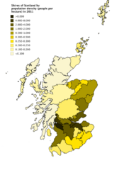
Description: A choropleth map showing the historical Shires of Scotland by population density (people per hectare) in 2011. Values were calculated by dividing the total population by area of these counties using data from the civil parishes from Scotland's Census. Some parishes do not have data in the Census (1 in Fife, 2 in Forfarshire, 1 in Lanarkshire, 2 in Peeblesshire and 2 in Perthshire), and these parishes are not counted in the population density figures of the shires.
Title: Shires of Scotland by population density (2011)
Credit: Own work
Author: JackintheBox
Usage Terms: Creative Commons Attribution-Share Alike 4.0
License: CC BY-SA 4.0
License Link: https://creativecommons.org/licenses/by-sa/4.0
Attribution Required?: Yes
Usos del archivo
La siguiente página enlaza a este archivo:
.png&oldid=2652482)

.png)