
Archivo: Scythia Minor map-en

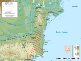
Descripción: The region of Scythia Minor during Antiquity, with approximate shoreline around 1 CE. UTM projection; WGS84 datum; shaded relief (composite image of N-W, W and N lightning positions). Age of settlement establishment/attestation (derived from the periodisation of Eastern Mediterranean Antiquity, accounting for the relatively late establishment of Roman rule in the region): Archaic and Classical: 7th-4th c. BCE Hellenistic: 3rd c. BCE-mid 1st c. CE High Roman: mid 1st-3rd c. CE Late Roman and Early Byzantine: 4th-7th c. CE
Título: Scythia Minor map-en
Créditos: Este gráfico vectorial, sin especificar según el W3C, fue creado con Inkscape .
Autor(a): Anonimu
Términos de Uso: Creative Commons Attribution-Share Alike 3.0
Licencia: CC BY-SA 3.0
Enlace de Licencia: https://creativecommons.org/licenses/by-sa/3.0
¿Se exige la atribución?: Sí
Usos del archivo
La siguiente página enlaza a este archivo:
