
Archivo: Satellite image Salar de Uyuni - Coipasa - Lake Poopo
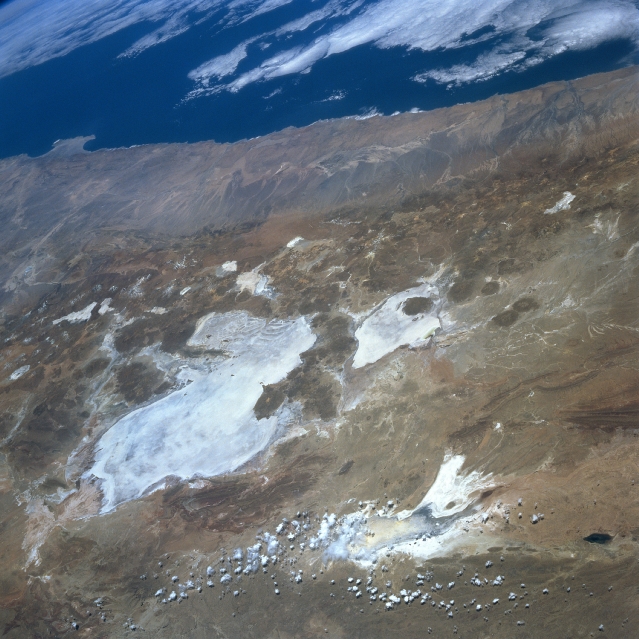
Descripción: Satellite image of Salar de Uyuni - Salar de Coipasa - Lake Poopo, Bolivia. (North at right) Lake Poopo, Salar de Uyuni, Bolivia September 1996. Numerous bright salars or salt flats are visible in this westerly view of the southwestern part of the Altiplano in Bolivia. Many volcanic cones (darker, roughly circular features) are visible, mainly along the western flanks of the two large salars, Uyuni (largest) and Coipasa. Lake Poopo, a light colored feature northeast of the two large salars, appears to be relatively devoid of standing water at the time this image was obtained. Some clouds partially obscure the southern end of intermittently water filled Lake Poopo. The Andes Mountains dramatically decrease in elevation in a relatively short horizontal distance along the western slopes of the mountains. Known as the Atacama Desert of northern Chile, this synoptic view shows a large section of one of the most arid regions on earth.
Título: Satellite image Salar de Uyuni - Coipasa - Lake Poopo
Créditos: NASA
Autor(a): NASA
Permiso: PD NASA
Términos de Uso: Dominio Público
Licencia: Dominio Público
¿Se exige la atribución?: No
Usos del archivo
La siguiente página enlaza a este archivo:
