
Archivo: Saint-Pierre and Miquelon EEZ map-fr

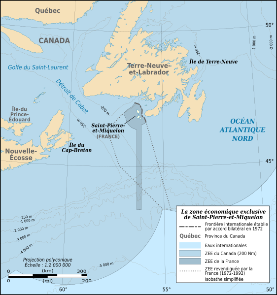
Descripción: Map in French of the Exclusive Economic Zone of the French oversea collectivity of Saint Pierre and Miquelon off the south coast of Newfoundland, Canada, with simplified bathymetric contours.
Título: Saint-Pierre and Miquelon EEZ map-fr
Créditos: Travail personnel Sources des données : NGDC World Data Bank II (domaine publique) NGDC ETOPO1 (domaine publique) Frontières : Canadiennes GéoBase Revendications françaises (1972-92) : http://www.saint-pierre-et-miquelon.developpement-durable.gouv.fr/IMG/pdf/dsbm_situation_de_l_existant_vf.pdf (pg. 8) Référence additionnelle : Christian Fleury, Saint-Pierre et Miquelon, îles frontière available on norois.revues.org
Autor(a): Eric Gaba (Sting - fr:Sting), Mapeh (discusión)
Permiso: Attribution and Share-Alike required Any use of this map can be made as long as you credit me (Eric Gaba – Wikimedia Commons user: Sting) as the author, the Canadian Géobase as source for the EEZ and Provinces boundaries and distribute the copies and derivative works under the same license(s) that the one(s) stated below. A message with a reply address would also be greatly appreciated.
Términos de Uso: Creative Commons Attribution-Share Alike 4.0
Licencia: CC BY-SA 4.0
Enlace de Licencia: https://creativecommons.org/licenses/by-sa/4.0
¿Se exige la atribución?: Sí
Usos del archivo
La siguiente página enlaza a este archivo:
