
Archivo: Ruhr area-administration
Tamaño de esta previsualización: 800 × 474 píxeles. Otras resoluciones: 320 × 190 píxeles | 1000 × 593 píxeles.
Archivo original (1000 × 593 píxeles; tamaño de archivo: 70 KB; tipo MIME: image/png)
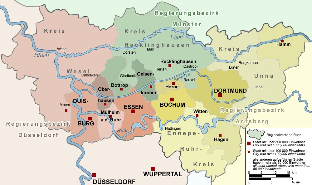
Descripción: Map of the administration of the Ruhr area, Germany – The map shows the administration (Regierungsbezirke, cities/districts, Regionalverband Ruhr and all cities with more than 50,000 inhabitants) of the Ruhr Area, Germany.
Título: Ruhr area-administration
Créditos: "drawn" by myself, Threedots (Daniel Ullrich), with Adobe Photoshop 6.0; used data set: official GeoData (former URL: www.ruhrgebiet.de/daten/geodatenserver.shtml) and several other maps
Autor(a): Threedots (Daniel Ullrich)
Términos de Uso: Creative Commons Attribution-Share Alike 3.0
Licencia: CC-BY-SA-3.0
Enlace de Licencia: http://creativecommons.org/licenses/by-sa/3.0/
¿Se exige la atribución?: Sí
Usos del archivo
La siguiente página enlaza a este archivo:

Todo el contenido de los artículos de la Enciclopedia Kiddle (incluidas las imágenes) se puede utilizar libremente para fines personales y educativos bajo la licencia Atribución-CompartirIgual a menos que se indique lo contrario.