
Archivo: Rotomahana Bathymetry

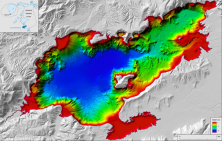
Descripción: Bathymetric map showing the lake floor of Lake Rotomahana (formed in the wake of the 1886 eruption of Mount Tarawera), including the potential location of the Pink and White Terraces and the former location of Lake Rotomakariri Bibliographic reference de Ronde C.E.J.1, Caratori Tontini F.1, Walker S.L.2, Black, J.1. 2020. Bathymetric Map of Lake Rotomahana, New Zealand. Lower Hutt (NZ): GNS Science. Scale 1:11,000. (GNS Science Rotorua Lakes map series). DOI: 10.21420/E4FK-8P15. ISBN: 978-1-99-001065-1 1. Institute of Geological and Nuclear Sciences Ltd., Lower Hutt, New Zealand. 2. Pacific Marine Environmental Laboratory, Seattle, USA.
Título: Rotomahana Bathymetry
Créditos: https://shop.gns.cri.nz/rl-rotomahana-pdf/
Autor(a): de Ronde C.E.J., Caratori Tontini F., Walker S.L., Black, J.
Términos de Uso: Creative Commons Attribution-Share Alike 3.0
Licencia: CC BY-SA 3.0
Enlace de Licencia: https://creativecommons.org/licenses/by-sa/3.0
¿Se exige la atribución?: Sí
Usos del archivo
La siguiente página enlaza a este archivo:
