
Archivo: Rodrigues Island bathymetric environment map-fr

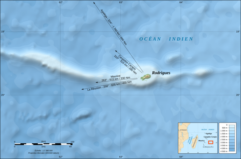
Descripción: Map in French of the bathymetric environment of Rodrigues Island, Mauritius, with indication of the bearing and distance of some surrounding islands (the length of the arrows is proportional to the distance). Note : The background map is a raster image embedded in the SVG file. Scale : 1:7,380,000 (accuracy: 1,845 m)
Título: Rodrigues Island bathymetric environment map-fr
Créditos: Trabajo propio Bathymetry : NGDC ETOPO1 ; Topographic data of the island : NASA Shuttle Radar Topography Mission (SRTM3 v.2) (public domain) ; Shoreline : created from Landsat ETM+ imagery (14.25 m resolution – public domain), completed with NASA SRTM Water Body Data ;
Autor(a): Eric Gaba (Sting - fr:Sting)
Permiso: Attribution and Share-Alike required Any use of this map can be made as long as you credit me (Eric Gaba – Wikimedia Commons user: Sting) as the author and distribute the copies and derivative works under the same license(s) that the one(s) stated below. A message with a reply address would also be greatly appreciated.
Términos de Uso: Creative Commons Attribution-Share Alike 4.0
Licencia: CC BY-SA 4.0
Enlace de Licencia: https://creativecommons.org/licenses/by-sa/4.0
¿Se exige la atribución?: Sí
Usos del archivo
La siguiente página enlaza a este archivo:
