
Archivo: Rif War map

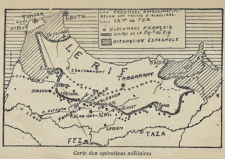
Descripción: Sketch map of Northern Morocco during the first half of the 1920s focussing on the theatre of war during the Rif War. The map shows the limits of the Riffian republic, with Spanish-occupied territory at both end (shaded areas). Riffian control had spilled over inside French Morocco; the dots represents French fortifications ("blockhaus") built to contain the Berber tribesmen who, the French feared, threatened Fez for a time. This map is contained in Pierre Sémard's book "La guerre du Rif" published in 1926.
Título: Rif War map
Créditos: BnF (Gallica)
Autor(a): Unspecified, possibly Pierre Sémard (1887-1942)
Términos de Uso: Dominio Público
Licencia: Dominio Público
¿Se exige la atribución?: No
Usos del archivo
La siguiente página enlaza a este archivo:
