
Archivo: Rhine watershed closer
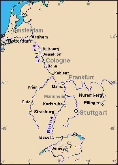
Description: Map of the Rhine watershed in northwest Germany, showing largest cities, islands and river names. Large city names (6) have been re-labeled with font-face Arial or Arial Narrow, as font-size 9 or 10; the island/region names are labeled in italic font. Germany contains over 3,500 cities/towns, but they are evenly dispersed around the main towns. This map has locator code "GermanyRhine" for use in map-locator templates, such as English Wiki Template:Location_map_GermanyRhine & Template:Location_map_skew (which skews northern coordinates for multiple map markers / labels, skew=0.91). The latitude/longitude coordinates are equirectangular, with longitudes parallel from south to north: the longitudes at the bottom range exactly 4-12 degrees, and at top, also range 4-12 degrees apart. The latitude is calibrated for exactly 46.5-53.5 degrees N. The original map image has a GFDL license; the extensions are as follows: narrowed 105px as 409px to magnify 26%; some river names have been added; bolded names of towns to be readable as 220px thumbnail size; added river name: Rhine, etc.
Title: Rhine watershed closer
Credit: Derivative of map (Wikipedia): en:Image:Rhine river 3.PNG (enlarging labels, dimming colors to CIA hues & magnified 26%).
Author: Wikid77 (derivative of map from WP User:Geo_Swan, cropping & enlarging labels)
Usage Terms: Creative Commons Attribution-Share Alike 3.0 truetrue
License: CC-BY-SA-3.0
License Link: http://creativecommons.org/licenses/by-sa/3.0/
Attribution Required?: Yes
Usos del archivo
Las siguientes páginas enlazan a este archivo:
