
Archivo: Raleigh-Durham-Cary CSA
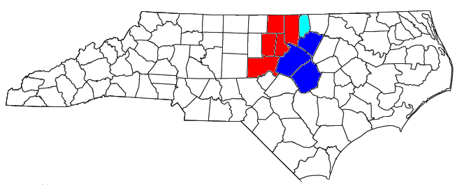
Description: Locator map of the Raleigh-Durham-Chapel Hill Combined Statistical Area in the north central part of the U.S. state of North Carolina. The three components of the CSA are colored separately: Durham-Chapel hill metropolitan area: red Raleigh-Cary metropolitan area: blue Henderson micropolitan area: light blue
Title: Raleigh-Durham-Cary CSA
Credit: Modified from this United States Census Bureau file, based on the following Census definitions list: OMB BULLETIN NO. 18-04: Revised Delineations of Metropolitan Statistical Areas, Micropolitan Statistical Areas, and Combined Statistical Areas, and Guidance on Uses of the Delineations of These Areas. Office of Management and Budget. September 14, 2018.
Author: User:Nyttend, Yassie
Permission: US Government work is public domain, and our work is Public domainPublic domainfalsefalse I, the copyright holder of this work, release this work into the public domain. This applies worldwide. In some countries this may not be legally possible; if so: I grant anyone the right to use this work for any purpose, without any conditions, unless such conditions are required by law.
Usage Terms: Public domain
License: Public domain
Attribution Required?: No
Usos del archivo
La siguiente página enlaza a este archivo:
