
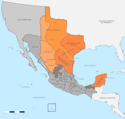
Archivo: Political divisions of Mexico 1836-1845 (location map scheme)

Tamaño de esta previsualización PNG del archivo SVG: 631 × 600 píxeles. Otra resolución: 252 × 240 píxeles.
Archivo original (archivo SVG, nominalmente 649 × 617 píxeles, tamaño de archivo: 467 KB)
Description: Political divisions of Mexico 1836-1845. Territory proclaimed its independency Territory claimed by the Republic of Texas Territory claimed by the Republic of the Rio Grande Rebellions
Title: Political divisions of Mexico 1836-1845 (location map scheme)
Credit: Own work Instituto Nacional de Estadística y Geografía (INEGI) File:Political divisions of Mexico 1836 (location map scheme).svg : Giggette derivative work Giggette
Author: Giggette
Usage Terms: Creative Commons Attribution-Share Alike 3.0
License: CC BY-SA 3.0
License Link: https://creativecommons.org/licenses/by-sa/3.0
Attribution Required?: Yes
Usos del archivo
Las siguientes páginas enlazan a este archivo:
.svg&oldid=2517804)

Todo el contenido de los artículos de la Enciclopedia Kiddle (incluidas las imágenes) se puede utilizar libremente para fines personales y educativos bajo la licencia Atribución-CompartirIgual a menos que se indique lo contrario.
.svg)