
Archivo: Polish-Lithuanian Commonwealth at its maximum extent-es

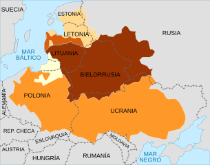
Descripción: A map showing the Polish-Lithuanian Commonwealth at its maximum extent following the Truce of Deulino, superimposed on present-day national borders. The map shows all of the territory that was ruled by Zygmunt III Waza in 1619 (the Polish monarch at that time), which made up the Commonwealth; it can be further divided up into: Kingdom of Poland Duchy of Prussia, Polish fief Grand Duchy of Lithuania Duchy of Courland, Lithuanian fief Livonia
Título: Polish-Lithuanian Commonwealth at its maximum extent-es
Créditos: Polish-Lithuanian Commonwealth at its maximum extent.svg Rzeczpospolita2nar.pt.png
Autor(a): Polish-Lithuanian Commonwealth at its maximum extent.svg: Samotny Wędrowiec (discusión · contribs.) Rzeczpospolita2nar.pt.png: Bonas (discusión · contribs.) derivative work: Rowanwindwhistler (discusión) work: Rowanwindwhistler (discusión)
Términos de Uso: Creative Commons Attribution-Share Alike 3.0
Licencia: CC BY-SA 3.0
Enlace de Licencia: https://creativecommons.org/licenses/by-sa/3.0
¿Se exige la atribución?: Sí
Usos del archivo
Las siguientes páginas enlazan a este archivo:
