
Archivo: Polish-Lithuania map (1450-1600)-es

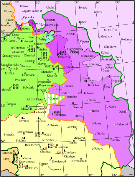
Descripción: Map showing the conflicts and territory of the union (later commonwealth) of Poland-Lithuania. National border Administrative or temporal division The Grand Duchy of Lithuania in 1450 Livonia Other rule Russia before 1494 Ceded to Russia in 1494 Ceded to Russia in 1503 Ceded to Russia in 1514 Ceded to Russia in 1536 Area recovered by Lithuania (Liubech) in 1508 Area recovered by Lithuania (Gomel) in 1537Union of Lublin: Territory of the Kingdom of Poland before the Union of Lublin Territory of the Grand Duchy of Lithuania after the Union of Lublin Territory lost from the Grand Duchy of Lithuania to the Kingdom of Poland immediately preceding the Union of Lublin (the Voivodeships of Kiev, Podlaskie, Bracław, and Volhynia) The Polish-Lithuania Commonwealth after the Union of Lublin Border between Poland and Lithuania after the Union of Lublin Significant battles fought by Poland-Lithuania. Red: against the Tartars; Black: against Russia. Year given in small type. Significant fortress
Título: Polish-Lithuania map (1450-1600)-es
Créditos: Polish-Lithuania map (1450-1600).svg
Autor(a): Polish-Lithuania map (1450-1600).svg: Grandiose (discusión · contribs.) derivative work: Rowanwindwhistler (discusión)
Términos de Uso: Creative Commons Attribution-Share Alike 4.0
Licencia: CC BY-SA 4.0
Enlace de Licencia: https://creativecommons.org/licenses/by-sa/4.0
¿Se exige la atribución?: Sí
Usos del archivo
La siguiente página enlaza a este archivo:
-es.svg&oldid=3362691)

-es.svg)