
Archivo: Pennsylvania swine flu map

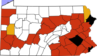
Descripción: This map shows 2009 swine-origin pandemic flu cases in Pennsylvania. It is a copy for convenience of the data that is updated daily at http://www.health.state.pa.us/H1N1Map/ . This is a modification of a map from David Benbennick (see Commons:United States county locator maps) to which style and class tags have been added to make it easy to address changes by listing counties near the beginning of the document. I haven't uploaded a separate all-blank version because it is probably easier to adapt this for other applications starting with this simple example. Just change the lists of counties and colors for each category, or add new similar categories.
Título: Pennsylvania swine flu map
Créditos: Map_of_Pennsylvania_highlighting_Wyoming_County.svg
Autor(a): David Benbennick derivative work: Mike Serfas (talk)
Términos de Uso: Dominio Público
Licencia: Dominio Público
¿Se exige la atribución?: No
Usos del archivo
La siguiente página enlaza a este archivo:
