
Archivo: Pagès Amérique Séptentrionale 1782 UTA
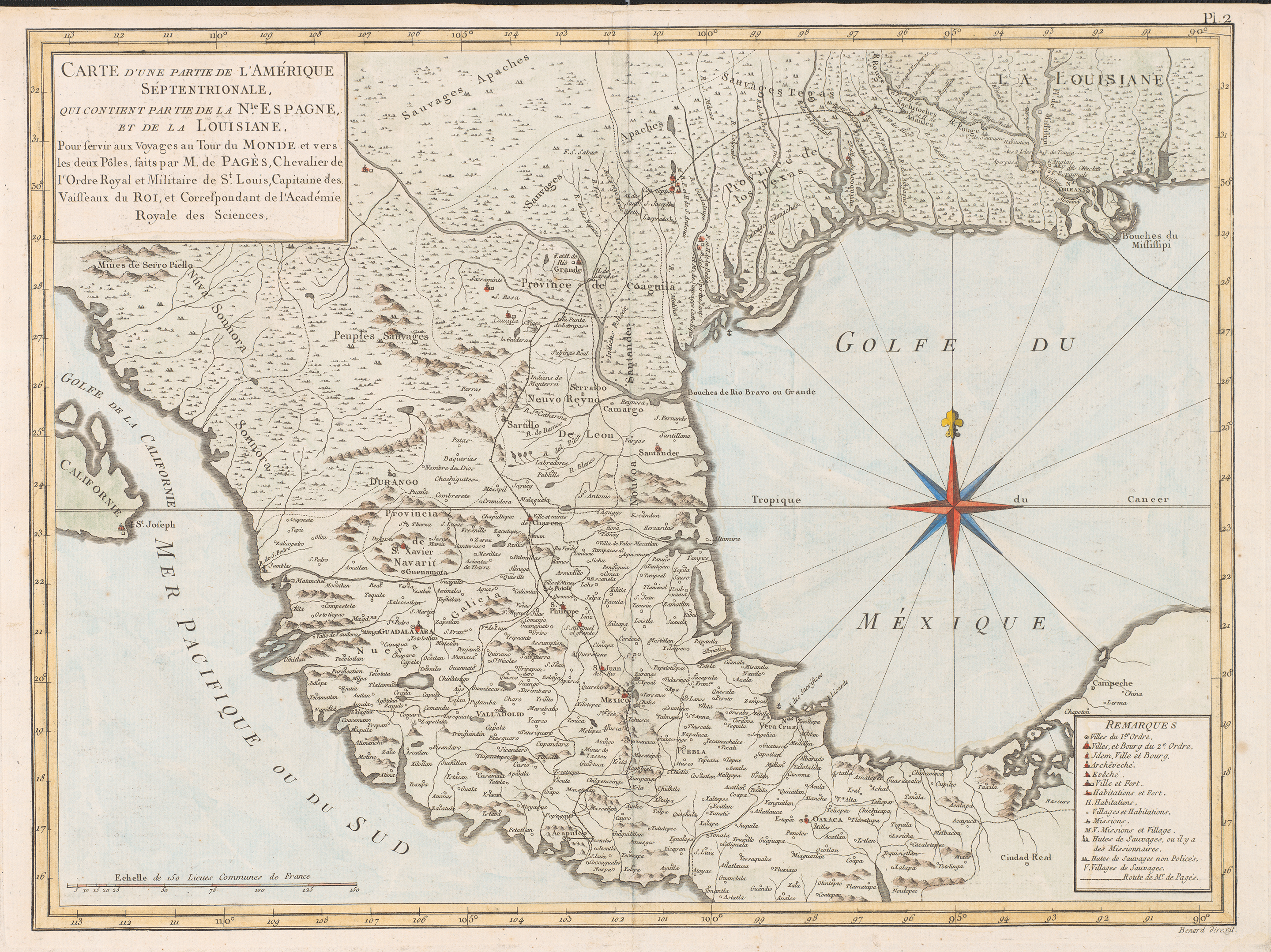
Descripción: This map illustrated the travels of Pierre Marie Francois, Vicomte de Pagès (1748-1793), a French naval officer who crossed what is now Texas and Mexico on the first part of a trip around the world. Pagès slipped into New Spain despite Spanish government restrictions on foreigners traveling in their colonies, and although he claimed his motives were scientific, he may have been acting as a spy. After his return to France, he recorded his memories of the trip in the book Voyages autour du monde (Paris, 1782) that included several maps compiled by "Bernard" who was presumably an engraver or publishing agent. The map here was based upon the author's recollections and available maps of Mexico. These probably included maps by Bellin and Bonne and, undoubtedly, Spanish scholar Alzate y Ramirez's 1768 map of New Spain, which had recently been published in Paris by the Académie des Sciences. The map shows the route of Pagès' travels between 1767 and 1768: Leaving Santo Domingo (prior to which he had sailed from Rochefort, France), he went to New Orleans and to Natchitoches in Spanish L[o]uisiana by way of the Mississippi and Red Rivers. From there he crossed what is now Texas along the Camino Real (Old San Antonio Road) and entered into what is present Mexico at Laredo. The map places three missions — Concepción, San José, and La Espada — along the San Antonio River and the fort or presidio of La Bahia and missions around it along the Guadalupe. From Laredo Pagès passed through Monterrey, Saltillo, Charcas, San Luis Potosi, San Felipe (Guanajuato), Mexico City, Cuernavaca, and Chilpancingo before heading westward on across the Pacific from Acapulco. Pagès' book soon appeared in an English translation Travels Round the World: in the years 1767, 1768, 1769, 1770, 1771 (2 vols.; London: J. Murray, 1791) — one of the first books on Texas in English.
Título: Carte d'une partie de l'Amérique Séptentrionale: qui contient partie de la Nle. Espagne, et de la Louisiane
Créditos: UTA Libraries Cartographic Connections: map / texto
Autor(a): François Pagès
Términos de Uso: Dominio Público
Licencia: Dominio Público
¿Se exige la atribución?: No
Usos del archivo
La siguiente página enlaza a este archivo:
