
Archivo: PIA13164 North Polar Cap Cross Section, Annotated Version

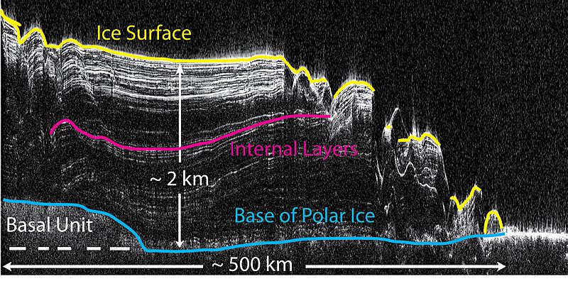
Descripción: This image shows a cross-section of a portion of the north polar ice cap of Mars, derived from data acquired by the Mars Reconnaissance Orbiter's Shallow Radar (SHARAD), one of six instruments on the spacecraft. The data depict the region's internal ice structure, with annotations describing different layers. The ice depicted in this graphic is approximately 2 kilometers (1.2 miles) thick and 250 kilometers (155 miles) across. White lines show reflection of the radar signal back to the spacecraft. Each line represents a place where a layer sits on top of another. Scientists study how thick the pancake-like layers are, where they bulge and how they tilt up or down to understand what the surface of the ice sheet was like in the past as each new layer was deposited.
Título: PIA13164 North Polar Cap Cross Section, Annotated Version
Créditos: Catalog page · Full-res (JPEG · TIFF)
Autor(a): NASA/JPL-Caltech/ASI/UT
Términos de Uso: Dominio Público
Licencia: Dominio Público
¿Se exige la atribución?: No
Usos del archivo
El siguiente archivo es un duplicado de éste (más detalles):
La siguiente página enlaza a este archivo:
