
Archivo: Niagara Falls, Image of the Day DVIDS704155

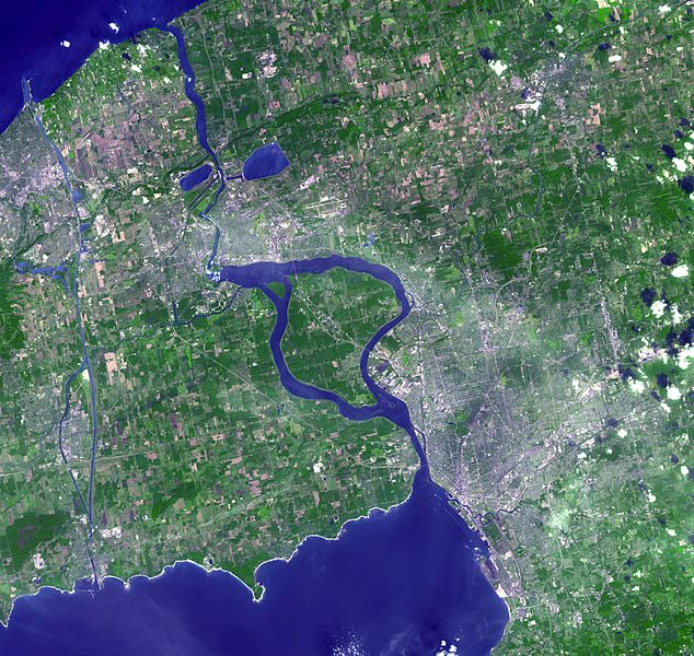
Descripción: The Niagara River (a Native American word for at the neck), linking Lake Erie and Lake Ontario, flows around Goat Island, and then plummets over Horseshoe and American Falls, better known as Niagara Falls. The port city of Buffalo, New York is located at the northeast corner of Lake Erie where the river first leaves the lake. The image also includes the infamous Love Canal. In the late 1970s and early 1980s, as a result of chemical wastes having been dumped in the area of the Love Canal from 1947 to 1952, the area was evacuated. In 1990, after a 12-year cleanup effort, the federal government declared parts of the area habitable and reopened those areas. This image was acquired on September 8, 2001 by the Advanced Spaceborne Thermal Emission and Reflection Radiometer (ASTER) on NASA's terra.nasa.gov/ Terra satellite. With its 14 spectral bands from the visible to the thermal infrared wavelength region, and its high spatial resolution of 15 to 90 meters (about 50 to 300 feet), ASTER images Earth to map and monitor the changing surface of our planet. Size: 56.4 x 53.4 km (35.0 x 33.1 miles) Location: 43.0 deg. North lat., 78.9 deg. West long. Orientation: North at top Image Data: green, red, near-infrared Original Data Resolution: 15 meters epr pixel Date Acquired: September 8, 2001Image courtesy NASA/GSFC/MITI/ERSDAC/JAROS, and U.S./Japan ASTER Science Team NASA Identifier: niagara_ast_2001251
Título: Niagara Falls, Image of the Day DVIDS704155
Créditos: https://www.dvidshub.net/image/704155 and NASA
Autor(a): Glenn Research Center
Términos de Uso: Dominio Público
Licencia: Dominio Público
¿Se exige la atribución?: No
Usos del archivo
La siguiente página enlaza a este archivo:
