
Archivo: New York's 4th congressional district (since 2023)

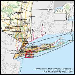
Descripción: The congressional district (since 2023), overlayed with other congressional districts and county boundaries, as well as commuter train lines, motorways, principal arterial roads, publicly-owned lands (including national forests and parks), and water areas in Downstate New York, with neighbouring states coloured in grey. Shapefiles from the United States Census Bureau, the New York Department of Transportation, the U.S. Geological Survey (USGS) Gap Analysis Project (GAP), and OpenStreetMap (© OpenStreetMap contributors), converted with Mapshaper (Mercator projection) and Inkscape.
Título: New York's 4th congressional district (since 2023)
Créditos: Trabajo propio
Autor(a): Twotwofourtysix
Términos de Uso: Creative Commons Attribution 4.0
Licencia: CC BY 4.0
Enlace de Licencia: https://creativecommons.org/licenses/by/4.0
¿Se exige la atribución?: Sí
Usos del archivo
La siguiente página enlaza a este archivo:
.svg&oldid=4631236)

.svg)