
Archivo: Municipalities in DN

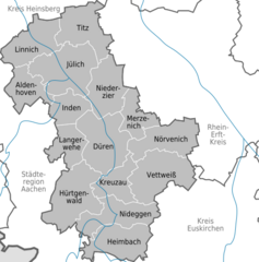
Descripción: Deutsch (de): Lagekarte von Kreis Düren in Nordrhein-Westfalen, Deutschland. @media all and (max-width:720px){.mw-parser-output table.multicol>tr>td,.mw-parser-output table.multicol>tbody>tr>td{display:block!important;width:100%!important;padding:0!important}.mw-parser-output table.multicol{width:100%!important}}.mw-parser-output table.multicol{border:0;border-collapse:collapse;background-color:transparent;padding:0}.mw-parser-output table.multicol>tr>td,.mw-parser-output table.multicol>tbody>tr>td{vertical-align:top} markierter Landkreis oder kreisfreie Stadt andere Landkreise und kreisfreie Städte im selben Regierungsbezirk andere Landkreise und kreisfreie Städte im (Bundes-)Land Sitz der Verwaltung eines Gemeindeverbands ausländische Staaten andere (Bundes-)Länder Seen und Meere Flüsse und Küstenlinien Siehe auch: Projekt Landkreiskarten English (en): Locator map of District of Düren in North Rhine-Westphalia, Germany. highlighted urban or rural district other urban or rural districts in same administrative district (Regierungsbezirke) other urban or rural districts in same state administrative centre of a municipalities association foreign countries other german states lakes and seas rivers and coastlines See also: Projekt Landkreiskarten (German) français (fr): Plan de localisation de l'arrondissement de Düren dans le Land Rhénanie-du-Nord-Westphalie, Allemagne. arrondissement ou villes-arrondissement marqués autres arrondissements ou villes-arrondissements dans le même district (Regierungsbezirke) autres arrondissements ou villes-arrondissements dans le même Land siège de l'administration d'un syndicat intercommunal autres pays autres Länder lacs et mers rivières Voir aussi: Projet Landkreiskarten (allemand) Nederlands (nl): Detailkaart van Kreis Düren in Nordrhein-Westfalen, Duitsland. gemarkeerde landkreis of kreisfreie stad andere landkreise en kreisfreie steden in dezelfde regierungsbezirk andere landkreise en kreisfreie steden in de deelstaat bestuurszetel van een gemeenteverband andere landen andere deelstaten meren en zeeën rivieren en kustlijnen Zie ook: Projekt Landkreiskarten (Duits) Esperanto (eo): Situomapo de komunumo nekonata en Kreis Düren, Nordrhein-Westfalen, Germanio. akcentita komunumo aliaj komunumoj en administra kunumunaro aliaj komunumoj en sama distrikto aliaj distriktoj en sama federacia lando administra centro de kunumunaro ŝtatoj krom Germanio aliaj federaciaj landoj de Germanio lagoj kaj maroj riveroj kaj marbordoj Vidu ankaŭ: Projekt Landkreiskarten (germane) മലയാളം (ml): ജർമ്മനിയിലെ North Rhine-Westphalia District of Düren, ഭൂപടസ്ഥാനം. എടുത്തുകാണിക്കുന്ന നാഗരിക അല്ലെങ്കിൽ ഗ്രാമ്യ ജില്ല അതേ ഭരണജില്ലയിലെ നാഗരിക അല്ലെങ്കിൽ ഗ്രാമ്യ ജില്ല (Regierungsbezirke) അതേ സംസ്ഥാനത്തിലെ നാഗരിക അല്ലെങ്കിൽ ഗ്രാമ്യ ജില്ല നഗരസഭാസമിതിയുടെ ഭരണനിർവഹണ കേന്ദ്രം വിദേശരാജ്യങ്ങൾ മറ്റു ജർമ്മൻ സംസ്ഥാനങ്ങൾ തടാകങ്ങളും കടലുകളും നദികളും തീരപ്രദേശങ്ങളും ഇതും കാണുക: Projekt Landkreiskarten (German)
Título: Municipalities in DN
Créditos:
Autor(a): TUBS
Términos de Uso: Creative Commons Attribution-Share Alike 3.0
Licencia: CC BY-SA 3.0
Enlace de Licencia: https://creativecommons.org/licenses/by-sa/3.0
¿Se exige la atribución?: Sí
Usos del archivo
La siguiente página enlaza a este archivo:
