
Archivo: Mescal Creek Road, Mount Baden-Powell, and Mountain High Resort

Tamaño de esta previsualización: 337 × 599 píxeles. Otras resoluciones: 135 × 240 píxeles | 1512 × 2688 píxeles.
Archivo original (1512 × 2688 píxeles; tamaño de archivo: 1,88 MB; tipo MIME: image/jpeg)
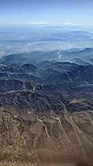
Description: Aerial view from the north of the San Gabriel Mountains showing Mescal Creek Road (right foreground, running to center), Mount Baden-Powell (above center, slightly right of center), and Mountain High Resort (ski area left of center). Behind Mount Baden-Powell, the San Gabriel and Morris reservoirs are visible, then the Los Angeles Basin, and the Palos Verdes peninsula and Santa Catalina Island in the far distance.
Title: Mescal Creek Road, Mount Baden-Powell, and Mountain High Resort
Credit: Own work
Author: Dicklyon
Usage Terms: Creative Commons Attribution-Share Alike 4.0
License: CC BY-SA 4.0
License Link: https://creativecommons.org/licenses/by-sa/4.0
Attribution Required?: Yes
Usos del archivo
La siguiente página enlaza a este archivo:

Todo el contenido de los artículos de la Enciclopedia Kiddle (incluidas las imágenes) se puede utilizar libremente para fines personales y educativos bajo la licencia Atribución-CompartirIgual a menos que se indique lo contrario.