
Archivo: Melissa 2025-10-28 1430Z
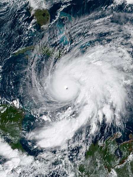
Descripción: This geo-color image of Hurricane Melissa was captured on October 28, 2025, at 14:40 UTC (9:40 AM Jamaica Local Time), utilizing the Advanced Baseline Imager (ABI) instrument aboard NOAA's GOES 19 satellite. Melissa, classified as the as the third Category 5 hurricane of the season, originated from a tropical wave off the coast of Africa during the 2025 Atlantic hurricane season, characterized by above-average activity. At the time of capture, Hurricane Melissa was progressing northeastward, poised for an eventual landfall in the Jamaica later that same day. The storm's devastating impact resulted in a casualty count of at least 44+ individuals in multiple countries. The financial toll incurred by Melissa is currently at least $8 Billion in 2025 U.S. dollars. Hurricane Melissa, at the time of imaging, was peaking in intensity as an extremely intense Category 5 hurricane, featuring 1-minute sustained winds of 185 mph (298 km/h; 161 kn) according to the Saffir-Simpson scale, coupled with a minimum central pressure of 892 mbar (26.3 inHg), the third most intense on record tying it with the 1935 Labor Day Hurricane 90 years prior to Melissa.
Términos de Uso: Dominio Público
Usos del archivo
La siguiente página enlaza a este archivo:
