
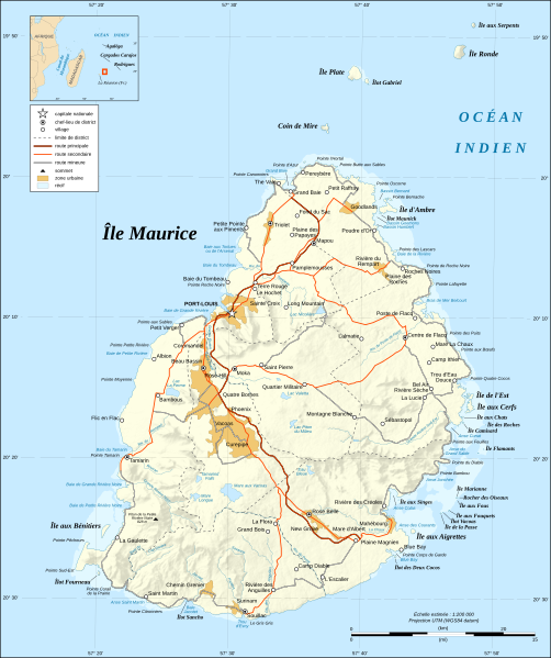
Archivo: Mauritius Island map-fr

Descripción: Map in French of Mauritius Island Note : The shaded relief is a raster image embedded in the SVG file.
Título: Mauritius Island map-fr
Créditos: Own work ; Shorelines : NASA Shuttle Radar Topography Mission (SRTM3 v.2) (public domain) ; Reef limits : created from Landsat ETM+ imagery (14.25 m resolution – public domain) ; Additional reference : Map of Mauritius' government.
Autor(a): Eric Gaba (Sting - fr:Sting)
Permiso: Attribution and Share-Alike required Any use of this map can be made as long as you credit me (Eric Gaba – Wikimedia Commons user: Sting) as the author and distribute the copies and derivative works under the same license(s) that the one(s) stated below. A message with a reply address would also be greatly appreciated.
Términos de Uso: Creative Commons Attribution-Share Alike 4.0
Licencia: CC BY-SA 4.0
Enlace de Licencia: https://creativecommons.org/licenses/by-sa/4.0
¿Se exige la atribución?: Sí
Usos del archivo
La siguiente página enlaza a este archivo:
