
Archivo: Maricopa County Incorporated and Planning areas Chandler highlighted

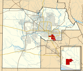
Description: This map shows the incorporated areas and Indian reservation boundaries in Maricopa County, Arizona, along with water bodies and major highways and roads. The City of Chandler is highlighted in red. Other incorporated cities are shown in gray, planning area borders for these cities and Indian reservation borders are shown as solid black lines. Changes from Previous Version: Updated the maps to include water bodies and to make "less boring" than the plain black/white/gray maps. Format was updated to match standards laid out by WikiProject Maps/Conventions. Map data is based on data from the following Webpage: Maricopa County Interactive GIS Map. I created this map in Inkscape.
Title: Maricopa County Incorporated and Planning areas Chandler highlighted
Credit: My own work, based on government information
Author: Ixnayonthetimmay
Permission: Public Domain
Usage Terms: Public domain
License: Public domain
Attribution Required?: No
Usos del archivo
La siguiente página enlaza a este archivo:
