
Archivo: Maria 2017-09-19 2115Z

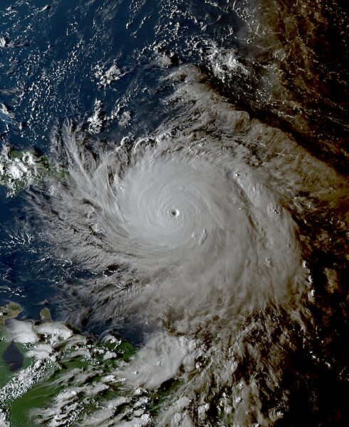
Descripción: This true-color representation of Hurricane Maria was captured on the evening of September 19, 2017, at 5:15 P.M. Puerto Rico Local Time (21:15 UTC), employing the Advanced Baseline Imager (ABI) instrument aboard the preliminary GOES 16 satellite. Launched jointly by NOAA and NASA in November 2016, the satellite and its instrumentation serve to monitor meteorological phenomena like Maria. Hurricane Maria, a formidable and expansive cyclone, emerged from an invest area within the primary development zone of the Atlantic Ocean during the 2017 Atlantic hurricane season. At the time of imaging, the storm exhibited near peak intensity strength, boasting maximum sustained winds of 175 mph (282 km/h) (150 knots) on the 1-minute Saffir-Simpson scale, classifying it as an extraordinarily potent Category 5 major hurricane. Its estimated minimum central pressure hovered around 915 mbar (27.0 inHg). Maria proceeded to devastate Puerto Rico, resulting in 2,975 fatalities (3,059 total fatalities including other islands and surrounding nations) and causing $91.6 billion in damages. This places it as the fourth (third at the time) most expensive tropical cyclone in history, following behind Katrina in 2005, Harvey earlier in the same season, and Ian which occurred five years later in 2022.
Título: Maria 2017-09-19 2115Z
Créditos: AWS S3 Explorer
Autor(a): ABI imagery from NOAA's GOES-16 Satellite
Términos de Uso: Dominio Público
Licencia: Dominio Público
¿Se exige la atribución?: No
Usos del archivo
Las siguientes páginas enlazan a este archivo:
