
Archivo: Map of the Empire of Trebizond

Tamaño de esta previsualización PNG del archivo SVG: 800 × 502 píxeles. Otra resolución: 320 × 201 píxeles.
Archivo original (archivo SVG, nominalmente 900 × 565 píxeles, tamaño de archivo: 20 KB)
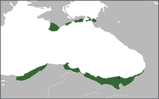
Description: Map of the approximate borders of the Empire of Trebizond shortly after the establishment of the Latin Empire, with the short-lived possessions in western Anatolia conquered by David Komnenos featured.
Title: Map of the Empire of Trebizond
Credit: Own work, source: File:Trebizond1204.png
Author: Samhanin, Ichthyovenator (PNG file author)
Usage Terms: Creative Commons Attribution-Share Alike 4.0
License: CC BY-SA 4.0
License Link: https://creativecommons.org/licenses/by-sa/4.0
Attribution Required?: Yes
Usos del archivo
La siguiente página enlaza a este archivo:

Todo el contenido de los artículos de la Enciclopedia Kiddle (incluidas las imágenes) se puede utilizar libremente para fines personales y educativos bajo la licencia Atribución-CompartirIgual a menos que se indique lo contrario.