
Archivo: Map of Ultras

Tamaño de esta previsualización: 800 × 489 píxeles. Otras resoluciones: 320 × 196 píxeles | 1110 × 679 píxeles.
Archivo original (1110 × 679 píxeles; tamaño de archivo: 299 KB; tipo MIME: image/png)
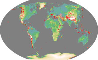
Description: Map of ultra prominences
Title: Map of Ultras
Credit: Self-made. I generated the base map using code I wrote to process the GTOPO30 data. The coastline was taken from the GSSHS coastline data bundled with GMT. The list of mountain peaks was ultimately derived from a list created by Jonathan de Ferranti from SRTM data, and which is not copyright. The degree-minute-second co-ordinates were converted into the Winkel-Tripel projection used in this map using code I wrote myself.
Author: Ras52
Usage Terms: Creative Commons Attribution 2.5
License: CC BY 2.5
License Link: https://creativecommons.org/licenses/by/2.5
Attribution Required?: Yes
Usos del archivo
La siguiente página enlaza a este archivo:

Todo el contenido de los artículos de la Enciclopedia Kiddle (incluidas las imágenes) se puede utilizar libremente para fines personales y educativos bajo la licencia Atribución-CompartirIgual a menos que se indique lo contrario.