
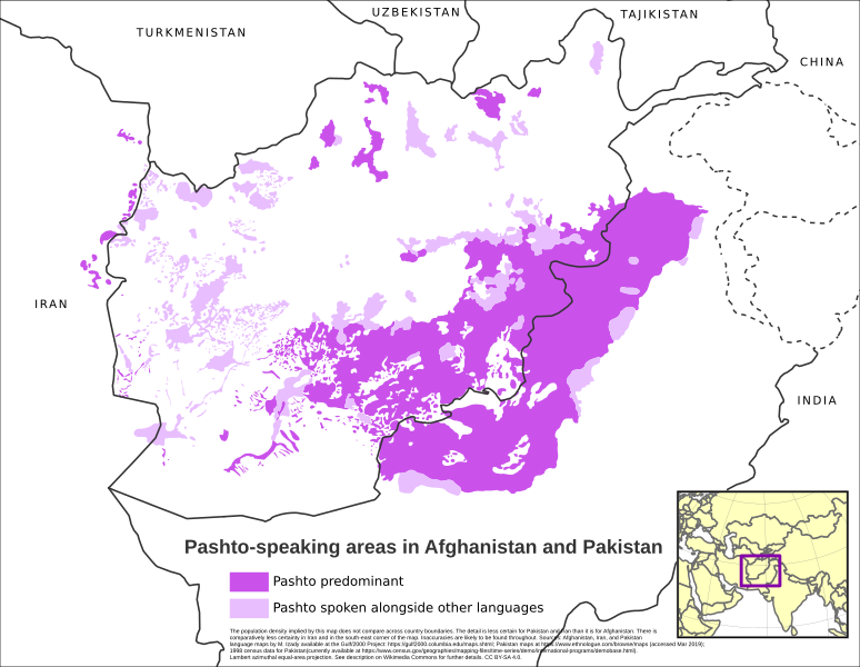
Archivo: Map of Pashto-speaking areas in Afghanistan and Pakistan

Descripción: The population density implied by this map does not compare across country boundaries. The detail of the map is less certain for Pakistan and Iran than it is for Afghanistan. There is comparatively less certainty in Iran and in the south-east corner of the map. Inaccuracies are likely to be found throughout the map. The map is mostly based on the Afghanistan, Iran, and Pakistan language maps by M. Izady available at the Gulf/2000 Project: https://gulf2000.columbia.edu/maps.shtml. The data for Pakistan also takes account of the Pakistan maps at https://www.ethnologue.com/browse/maps (accessed Mar 2019), and the language data from the 1998 census (currently available at https://www.census.gov/geographies/mapping-files/time-series/demo/international-programs/demobase.html; the version accessed is from Feb 2017). The map uses the Lambert azimuthal equal-area projection.
Título: Map of Pashto-speaking areas in Afghanistan and Pakistan
Créditos: Trabajo propio
Autor(a): Uanfala
Términos de Uso: Creative Commons Attribution-Share Alike 4.0
Licencia: CC BY-SA 4.0
Enlace de Licencia: https://creativecommons.org/licenses/by-sa/4.0
¿Se exige la atribución?: Sí
Usos del archivo
La siguiente página enlaza a este archivo:
