
Archivo: Map of Clear Creek County, Colorado

Tamaño de esta previsualización: 800 × 559 píxeles. Otras resoluciones: 320 × 224 píxeles | 1829 × 1279 píxeles.
Archivo original (1829 × 1279 píxeles; tamaño de archivo: 14 KB; tipo MIME: image/png)
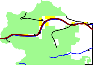
Description: A map of Clear Creek County, Colorado. The dark red line is Interstate 70. Black lines are other roads. Dots are towns. The light green area is Arapaho National Forest and other national forest. Yellow is BLM land. David Benbennick made this map with data from nationalatlas.gov. Eventually I'll upload the Metapost script I used. In the mean time, see map.mp.
Title: Map of Clear Creek County, Colorado
Credit: Own work
Author: David Benbennick
Usage Terms: Public domain
License: Public domain
Attribution Required?: No
Usos del archivo
La siguiente página enlaza a este archivo:

Todo el contenido de los artículos de la Enciclopedia Kiddle (incluidas las imágenes) se puede utilizar libremente para fines personales y educativos bajo la licencia Atribución-CompartirIgual a menos que se indique lo contrario.