
Archivo: MapNieuwpoort

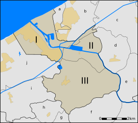
Descripción: Map of Nieuwpoort, West-Flanders, Belgium, neighbourhoods within the municipality and its neighbours. Nieuwpoort: I. Nieuwpoort II. Sint-Joris III. RamskapelleNeighbouring villages: a. Lombardsijde (Middelkerke) b. Westende (Middelkerke) c. Slijpe (Middelkerke) d. Mannekensvere (Middelkerke) e. Schore (Middelkerke) f. Pervijze (Diksmuide) g. Veurne h. Booitshoeke (Veurne) i. Wulpen (Koksijde) j. Oostduinkerke (Koksijde) The orange/yellow areas are urban areas; the other areas are rural areas with lower density population.
Título: MapNieuwpoort
Créditos: Trabajo propio
Autor(a): nl:User:LimoWreck
Términos de Uso: Creative Commons Attribution 2.5
Licencia: CC BY 2.5
Enlace de Licencia: https://creativecommons.org/licenses/by/2.5
¿Se exige la atribución?: Sí
Usos del archivo
La siguiente página enlaza a este archivo:
