
Archivo: MaineBoundaryDispute

Tamaño de esta previsualización: 424 × 599 píxeles. Otras resoluciones: 170 × 240 píxeles | 780 × 1102 píxeles.
Archivo original (780 × 1102 píxeles; tamaño de archivo: 306 KB; tipo MIME: image/jpeg)
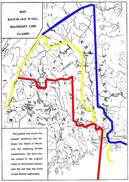
Description: Map showing competing proposals for the boundary line between the US state of Maine and the British (now Canadian) province of New Brunswick. The red line marks the British proposal, the blue line marks the US proposal, and the yellow line marks the line agreed in the 1842 Webster-Ashburton Treaty, which resolved virtually all of the outstanding boundary issues in this area.
Title: MaineBoundaryDispute
Credit: Base map: http://books.google.com/books?id=BEsyAQAAMAAJ&dq=%22fort%20sullivan%22%20eastport%20named&pg=PA134-IA1#v=onepage&q=sullivan&f=false Annotations: own work
Author: User:Magicpiano
Usage Terms: Public domain
License: Public domain
Attribution Required?: No
Usos del archivo
La siguiente página enlaza a este archivo:

Todo el contenido de los artículos de la Enciclopedia Kiddle (incluidas las imágenes) se puede utilizar libremente para fines personales y educativos bajo la licencia Atribución-CompartirIgual a menos que se indique lo contrario.