
Archivo: Lizars Mexico & Guatimala 1836 UTA

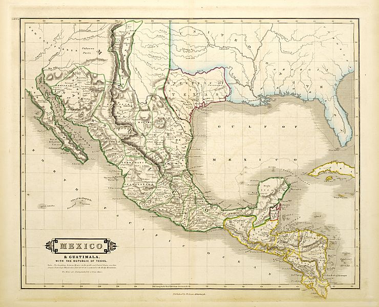
Descripción: Shortly after Texas declared its independence from Mexico in 1836, the Edinburgh painter, engraver, printer, cartographer, lithographer, and publisher William Home Lizars (1788-1859), brother of Daniel Lizars II (1793-1875) updated the original plate for the map of Mexico & Guatemala to include the new republic. He added the towns of Galveston, Harrisburg, Brazoria, S. Felipe de Austin (although recently destroyed), Bejar, and "S. Jose" (probably intended to represent Goliad). Lizars made no further improvements to the general cartographic shape of the republic except to show the Nueces River as the southern boundary and the western boundary curving to the point where the 100th meridian strikes the Red River. The map continues to show Mexico's administrative districts as Spanish Intendencies (Intendencias) and Internal Provinces (Provincias Internas) over fifteen years since Mexico's independence.
Título: Mexico & Guatimala
Créditos: UTA Libraries Cartographic Connections: map / texto
Autor(a): William Home Lizars
Términos de Uso: Dominio Público
Licencia: Dominio Público
¿Se exige la atribución?: No
Usos del archivo
La siguiente página enlaza a este archivo:
