
Archivo: Lidar P1270901

Tamaño de esta previsualización: 450 × 600 píxeles. Otras resoluciones: 180 × 240 píxeles | 1920 × 2560 píxeles.
Archivo original (1920 × 2560 píxeles; tamaño de archivo: 1,71 MB; tipo MIME: image/jpeg)
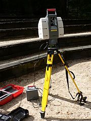
Description: This Leica terrestrial lidar (light detection and ranging) scanner (TLS) may be used to scan buildings, rock formations, etc., to produce a 3D model. The TLS can aim its laser beam in a wide range: its head rotates horizontally, a miror flips vertically. The laser beam is used to measure the distance to the first object on its path. Model: Leica HDS-3000 The Lidar was being demonstrated at UC Santa Cruz when the photo was taken.
Title: Lidar P1270901
Credit: Own work
Author: David Monniaux
Usage Terms: Creative Commons Attribution-Share Alike 3.0
License: CC-BY-SA-3.0
License Link: http://creativecommons.org/licenses/by-sa/3.0/
Attribution Required?: Yes
Usos del archivo

Todo el contenido de los artículos de la Enciclopedia Kiddle (incluidas las imágenes) se puede utilizar libremente para fines personales y educativos bajo la licencia Atribución-CompartirIgual a menos que se indique lo contrario.