
Archivo: Leimen in HD

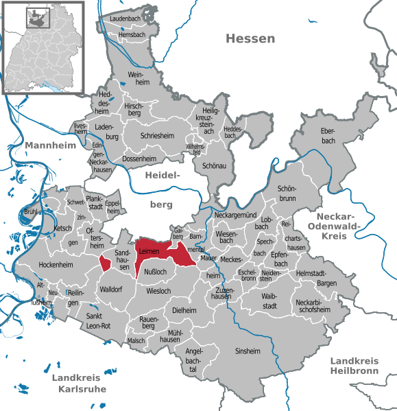
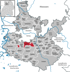
Description: Deutsch (de): Lagekarte von Leimen, Rhein-Neckar-Kreis, Baden-Württemberg, Deutschland. markierte Kommune andere Kommune im Gemeindeverband andere Kommunen im Landkreis andere Landkreise im (Bundes-)land Sitz der Verwaltung eines Gemeindeverbands ausländische Staaten andere (Bundes-)Länder Seen und Meere Flüsse und Küstenlinien See also: Projekt Landkreiskarten English (en): Locator map of Leimen in Rhein-Neckar-District, Baden-Württemberg, Germany. highlighted municipality other municipalities in administrative body (Gemeindeverband, etc.) other municipalities in same district other districts in same state administrative centre of a municipalities association foreign countries other german states lakes and seas rivers and coastlines See also: Projekt Landkreiskarten (German) français (fr): Plan de localisation de la municipalité Leimen dans L'arrondissement de Rhin-Neckar dans Bade-Wurtemberg, Allemagne. la municipalité marqués autres municipalités dans le même canton (Amt) autres municipalités dans le même arrondissement autres arrondissements dans le même Land siège de l'administration d'un syndicat intercommunal autres pays autres Länder allemands lacs et mers rivières Voir aussi: Projet Landkreiskarten (allemand) hornjoserbsce (hsb): Poziciska karta gmejny Leimen, Rhein-Neckar-Kreis, Baden-Württemberg, Němska. wuzběhnjena gmejna druhe gmejny w administratiwnym zwjazku (zarjadniski zwjazk etc.) druhe gmejny w samsnym wokrjesu druhe wokrjesny w samsnym kraju administratiwne srjedźišćo gmejnskeho zwjazka wukraj druhe němske kraje jězory a morja rěki a pobrjóhi Hlej tež: projekt Landkreiskarten (němsce) Nederlands (nl): Detailkaart van Leimen in de Rhein-Neckar-Kreis, Baden-Württemberg, Duitsland. gemarkeerde gemeente andere gemeenten in het gemeenteverband andere gemeenten in de landkreis andere landkreise in de deelstaat Bestuurszetel van een gemeenteverband andere landen andere deelstaten meren en zeeën rivieren en kustlijnen Zie ook: Projekt Landkreiskarten (Duits) Esperanto (eo): Situomapo de Leimen en distrikto Rhein-Neckar, Baden-Virtembergo, Germanio. akcentita komunumo aliaj komunumoj en administra kunumunaro aliaj komunumoj en sama distrikto aliaj distriktoj en sama federacia lando administra centro de kunumunaro ŝtatoj krom Germanio aliaj federaciaj landoj de Germanio lagoj kaj maroj riveroj kaj marbordoj Vidu ankaŭ: Projekt Landkreiskarten (germane) മലയാളം (ml): ജർമ്മനിയിലെ Baden-Württemberg, Rhein-Neckar-District, Leimen ഭൂപടസ്ഥാനം. എടുത്തുകാണിക്കുന്ന നഗരസഭ ഭരണതലത്തിലുള്ള മറ്റ് നഗരസഭകൾ (ഗെമിൻഡർവാർഡ്, തുടങ്ങിയവ.) അതേ ജില്ലയിലുള്ള മറ്റ് നഗരസഭകൾ അതേ സംസ്ഥാനത്തുള്ള മറ്റ് ജില്ലകൾ നഗരസഭാ സമിതിയുടെ ഭരണനിർവഹണ കേന്ദ്രം വിദേശരാജ്യങ്ങൾ മറ്റ് ജർമ്മൻ സംസ്ഥാനങ്ങൾ തടാകങ്ങളും കടലുകളും നദികളും തീരപ്രദേശങ്ങളും ഇതും കാണുക: Projekt Landkreiskarten (German)
Title: Leimen in HD
Credit: This W3C-unspecified vector image was created with Adobe Illustrator. Own work, based on: *File:Municipalities in Baden-Württemberg.svg by TUBS *File:Baden-Württemberg HD (district).svg by TUBS *Versions later 2013/06 based on: Contains map data © OpenStreetMap contributors, made available under the terms of the Open Database License (ODbL). The ODbL does not require any particular license for maps produced from ODbL data; map tiles produced by the OpenStreetMap foundation are licensed under the CC-BY-SA-2.0 licence, but maps produced by other people may be subject to other licences.Open Database LicenseODbLhttp://opendatacommons.org/licenses/odbl/1.0/true
Author: Hagar66 based on work of TUBS
Usage Terms: Public domain
License: Public domain
Attribution Required?: No
Usos del archivo
La siguiente página enlaza a este archivo:
