
Archivo: KentuckyRiver watershed
No disponible en mayor resolución.
KentuckyRiver_watershed.png (300 × 221 píxeles; tamaño de archivo: 63 KB; tipo MIME: image/png)
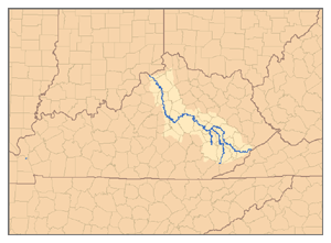
Description: This is a map of the Kentucky River watershed, showing the North Fork, Middle Fork, and South Fork tributaries. I, Pfly, made it, based on USGS data.
Title: KentuckyRiver watershed
Credit: Own work
Author: Pfly
Usage Terms: Creative Commons Attribution-Share Alike 2.5
License: CC BY-SA 2.5
License Link: http://creativecommons.org/licenses/by-sa/2.5
Attribution Required?: Yes
Usos del archivo
Las siguientes páginas enlazan a este archivo:

Todo el contenido de los artículos de la Enciclopedia Kiddle (incluidas las imágenes) se puede utilizar libremente para fines personales y educativos bajo la licencia Atribución-CompartirIgual a menos que se indique lo contrario.